


Church of Holy Spirit Žehra
Church of the Holy Spirit is the late-roman sacral building from the second half of the 13th century located in the village of Žehra in the district Spišská Nová Ves in the Košice region. Most valuable monuments in the church wall paintings, forming a complex of iconographic cycle. They cover ...


Historical exposition - Šariš Museum - Bardejov
The Historical Exposition Free Royal Town of Bardejov of Šariš Museum in Bardejov is located in a historical building, the Gothic-Renaissance Town Hall, built in 1505 - 1511. It presents the medieval history of Bardejov, from the first written record in 1241 to the end of the 18th century, its economic, social, and cultural life. The biggest attention is paid to the 15th and 16th centuries, when Bardejov reached the top of its fame and wealth. The exhibited items document developed crafts, craftsmen's lives, trade, textile production, form and execution of town administration, town's right for self-defence, medieval book culture, education and fine arts. The most valuable exhibits Group of sculptures called Small Calvary, made by the Master Paul from Levoča (a.k.a. Leuschau, Leutsovia) in 1520 St Nicholas's Altar from 1524 Janos Szilasi's Cup - made by a major Levoča goldsmith in 2nd half of 18th century Set of Renaissance burghers' epitaphs from the 17th century Queen Elizabeth's ring with brilliants The town hall is a part of the World Heritage Site - the historical center of Bardejov was entered in year 2000 into UNESCO World Heritage list.


")


")


Eastern Tatras
Location
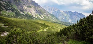
Eastern Tatras (in Slovak Východné Tatry) mountains as geomorphologic sub-whole of whole Tatra mountains (in Slovak Tatry) is located in northern Slovakia. It is located in Prešov Region (Prešovský kraj) - in districts Poprad and Kežmarok.
Area
Eastern Tatras (Východné Tatry) ...
Eastern Tatras
Eastern Tatras (in Slovak Východné Tatry) mountains as geomorphologic sub-whole of whole Tatra mountains (in Slovak Tatry) is located in northern Slovakia. It is located in Prešov Region (Prešovský kraj) - in districts Poprad and Kežmarok. Eastern Tatras (Východné Tatry) mountains have an area of 405 km² (40 500 ha). The highest peak Eastern Tatras (Východné Tatry) is Gerlach Peak (Gerlachovský štít) - 2 655 m. a.s.l., which is also the highest peak in Slovakia. More information can be found in the Hills and peaks section. From a geomorphological point of view Eastern Tatras (Východné Tatry) as a geomorphological sub-whole is part of whole Tatras (Tatry). Sub-whole Eastern Tatras (Východné Tatry) is divided into parts: Belianske Tatras (Belianske Tatry), High Tatras (Vysoké Tatry). More information can be found in the Division section.


")


")


